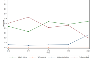
A Look Backwards at Early Voting (Trends)
We provide a historical snapshot of early voting trends before it is too late to inform what is happening/ may happen in this 2022 midterm early voting period.

We provide a historical snapshot of early voting trends before it is too late to inform what is happening/ may happen in this 2022 midterm early voting period.
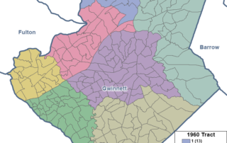
We take a close look at the past and present of census tracts, a key reporting unit for Census data--and critical geography for figuring out (along with those data) eligible areas for grant funding.
Was the pandemic a millstone for Milestones test participation in 2021?
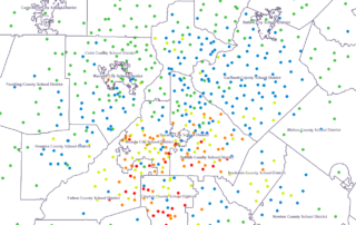
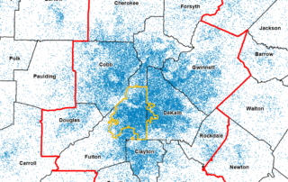
Where do the school-aged kids without internet access (or a computer) live in our Atlanta Region?. And are there correlations of higher poverty with the home locations of school-aged kids without access?
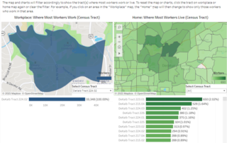
Our updated Commuting Dashboard gives an immediate snapshot of the commuting landscape, and enables custom analysis of patterns by census tracts of job locations and worker residences
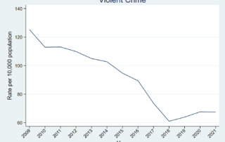
A deeper dive into City of Atlanta crime rates explores how historical trends vary by Neighborhood Planning Unit.
The Census Bureau's Small Area Income and Poverty Estimates give us a view into how poverty has changed across Georgia counties.
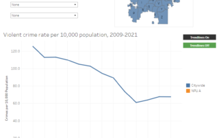
Crime is a top concern across the metro. Here, we compare perceptions and reality through an examination of crime rates for the city of Atlanta since 2009. The data reveal that crime rates are near historical lows in most categories.
An animated map showing how our diverse population has grown and moved over time.
An animation showing population growth at the Census tract level over the past 30 years illustrates where and how we've grown since 1990.