Metro Atlanta’s Wish List: Resident Priorities Going into 2026
What solutions do Metro Atlantans prefer for some of our region’s most pressing challenges?

What solutions do Metro Atlantans prefer for some of our region’s most pressing challenges?
Exploring where under- and pre-construction GDOT projects are concentrated around the metro.
Introducing a new way of visualizing and summarizing statewide projects by the Georgia Department of Transportation.
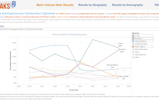
What were Atlanta resident opinions on transportation in the 2024 Metro Atlanta Speaks?
Many different ways to (and measures for) of look at congestion, by metro...
Work commutes! How? How long? And to where? ARC County comparisons!
How far, to where, and how v.v. work? Twists and turns in Atlanta MSA commuting trends over the last decade-plus
Metro Atlanta Speaks: Track the change in the biggest problem concerning Metro Atlantans over the years (to 2024) --starting in 2016
Metro Atlanta Speaks: The new and improved user-driven experience! A walk through the dashboard
Explore the New Metro Atlanta Speaks 2023 Dashboard to see regional resident opinions on many topics. We dive into an economic rabbit hole as one branch of dashboard-driven exploration