
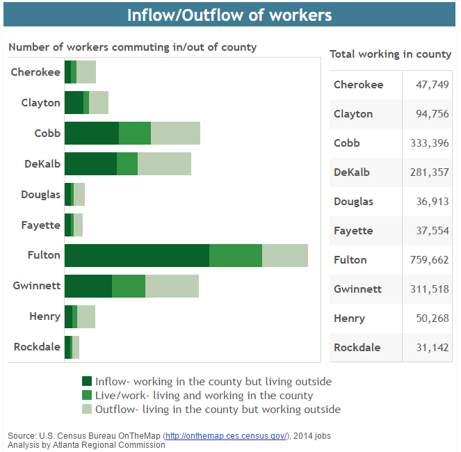
Transportation Tuesday: Commuting between Counties
For each of the ten core metro Atlanta counties, this chart shows the number of [...]

Monday Mapday: Educational Attainment
Which cities have the highest educational attainment levels? This map shows the percentage of residents [...]

Regional Snapshot: October 2016
Take a look at October's Regional Snapshot to gear up for the election and see [...]

The Quarter Update: October 2016
It's that time of the year when we take a look to see how our [...]

Transportation Tuesday: Congestion Costs
This visualization shows traffic congestion costs per commuter throughout the U.S. Atlanta ranks on the [...]
Monday Mapday: Patents Filed
Trends in patents are a leading indicator for higher-wage job growth. When there are high amounts [...]

Transportation Tuesday: Worst Traffic Jams in September
The lists and maps below show the Top 10 Worst Bottlenecks in September 2016 in [...]

Monday Mapday: Fastest Growing Metros
This map shows the top twenty metros that had the greatest increase in population from [...]

Where are the Voters? Voter Registration and Turnout in Metro Atlanta (2004 to 2012)
Election Day is just 39 days away and there are only 12 days left to register to [...]
Transportation Tuesday: Transportation and Warehousing Industry
This map shows areas in metro Atlanta that have the greatest number of employees working [...]