
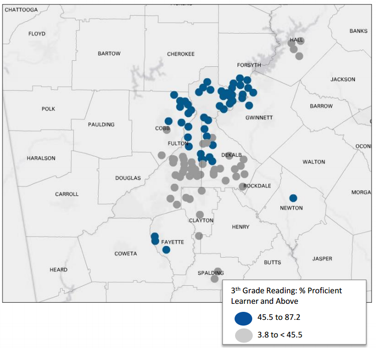
Monday Mapday: Reading Proficiency in Elementary Schools
This map, from our latest Regional Snapshot: Reading Matters and Math Counts, shows the 50 schools with the [...]

Transportation Tuesday: 500,000 Visitors in Atlanta on Labor Day Weekend
An estimated 500,000 people visited Atlanta on Labor Day weekend to attend various holiday events. To [...]

Regional Snapshot: Reading Matters and Math Counts
With a new school year starting, education is on a lot of minds...including ours! [...]
Monday Mapday: Population Age 65+ in Poverty
The blue areas in this map highlight neighborhoods in metro Atlanta that have a high [...]

Transportation Tuesday: Commuting to Midtown
Midtown Transportation is a Transportation Management Association (TMA) that works with employers in midtown Atlanta [...]

Monday Mapday: Building Permit Activity
This map shows the top twenty metros that had the greatest increase in building permits [...]

Transportation Tuesday: Worst Traffic Jams in August
Where were the worst traffic jams during August? This map shows the top 10 bottlenecks [...]

Metro Atlanta Speaks Spotlight: What Does Douglas County Think?
More Douglas County residents think Transportation is the biggest problem in metro Atlanta compared to [...]

Transportation Tuesday: Long commute – driving alone
This map shows neighborhoods in metro Atlanta where the mean travel time to work is [...]

Monday Mapday: Average Family Size
In metro Atlanta, the average family size is 3.41 (a "family" consists of at least two [...]