
In a recent blog post, we observed that the City of Atlanta was one of the fastest-growing cities in the nation in terms of absolute growth between 2024 and 2025. This growth outpaced the Atlanta Metropolitan Statistical Area (MSA) as a whole, despite robust growth at the edges of the region, also documented in this post. A longer, five-year timeframe shows the city growing at roughly the same pace as the MSA. What’s up with Atlanta’s population? How does the city compare to the rest of Fulton and DeKalb Counties[1]? We full yet?
As noted in a previous post, the City of Atlanta started as a circle with 1-mile radius at its incorporation in 1847, expanded gradually over time and then more than tripled in area overnight on New Year’s Day, 1952. Though there were smaller additional annexations over time[2], Atlanta’s territory has been stable enough since 1952 that 1960 provides a meaningful starting point for analysis. Figure 1 shows the city’s population from 1960 through 2020 measured by the decennial Censuses.
Figure 1: City of Atlanta Population by Decade, 1960-2020
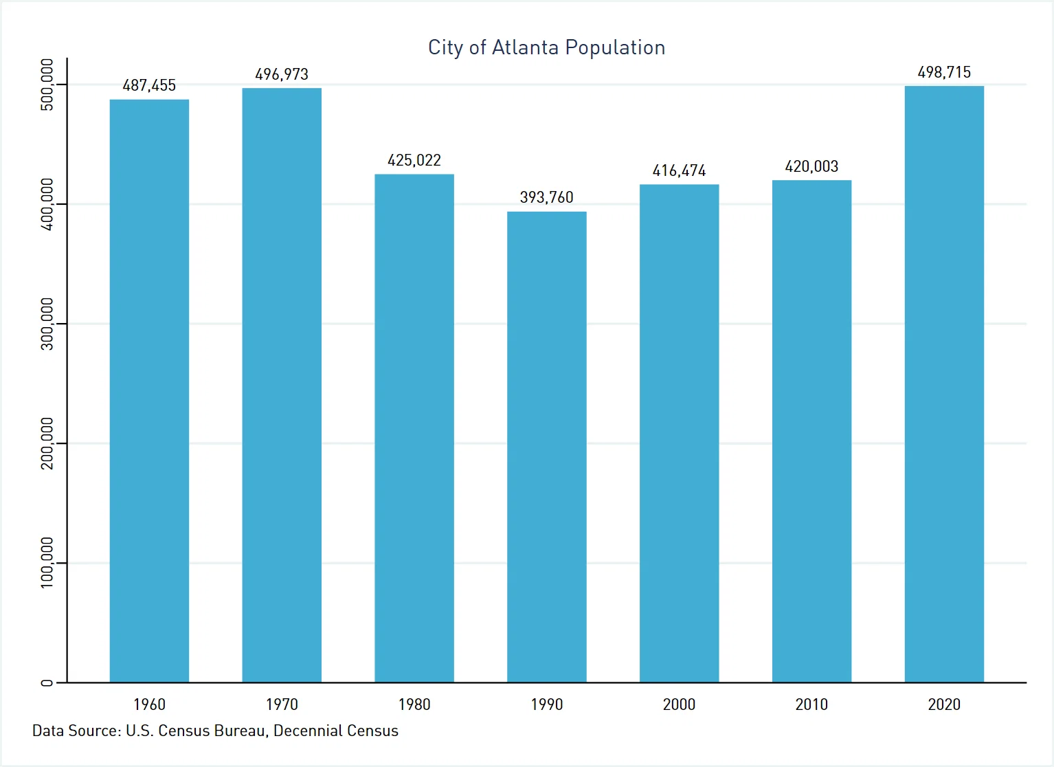
This graph shows that the city’s population initially peaked sometime around 1970. We cannot say precisely when, because the Census Bureau only began producing annual population estimates for cities in the 2000s. Atlanta lost 103,213 people, or almost 21% of the population over the following two decades. This is consistent with the narrative of population draining from central cities to the suburbs.
But that narrative is only half the story. The City of Atlanta subsequently recovered to just over its 1970 population level by 2020. Thanks to annexations, however, the city also occupies more area (approximately 136.4 square miles) today than in 1970 (about 132.5 square miles). The result is that Atlanta’s population density in 2020 (3,656.3 people per square mile) was actually a bit lower than it was back in 1970 (3,750.7 people per square mile). Thus, people who claim “we full” don’t have the full story.
We can utilize the Census Bureau’s intercensal and postcensal estimates[3] to examine annual population change for the City of Atlanta beginning in 2000, as presented in Figure 2.[4]
Figure 2: City of Atlanta Population, 2000-2025
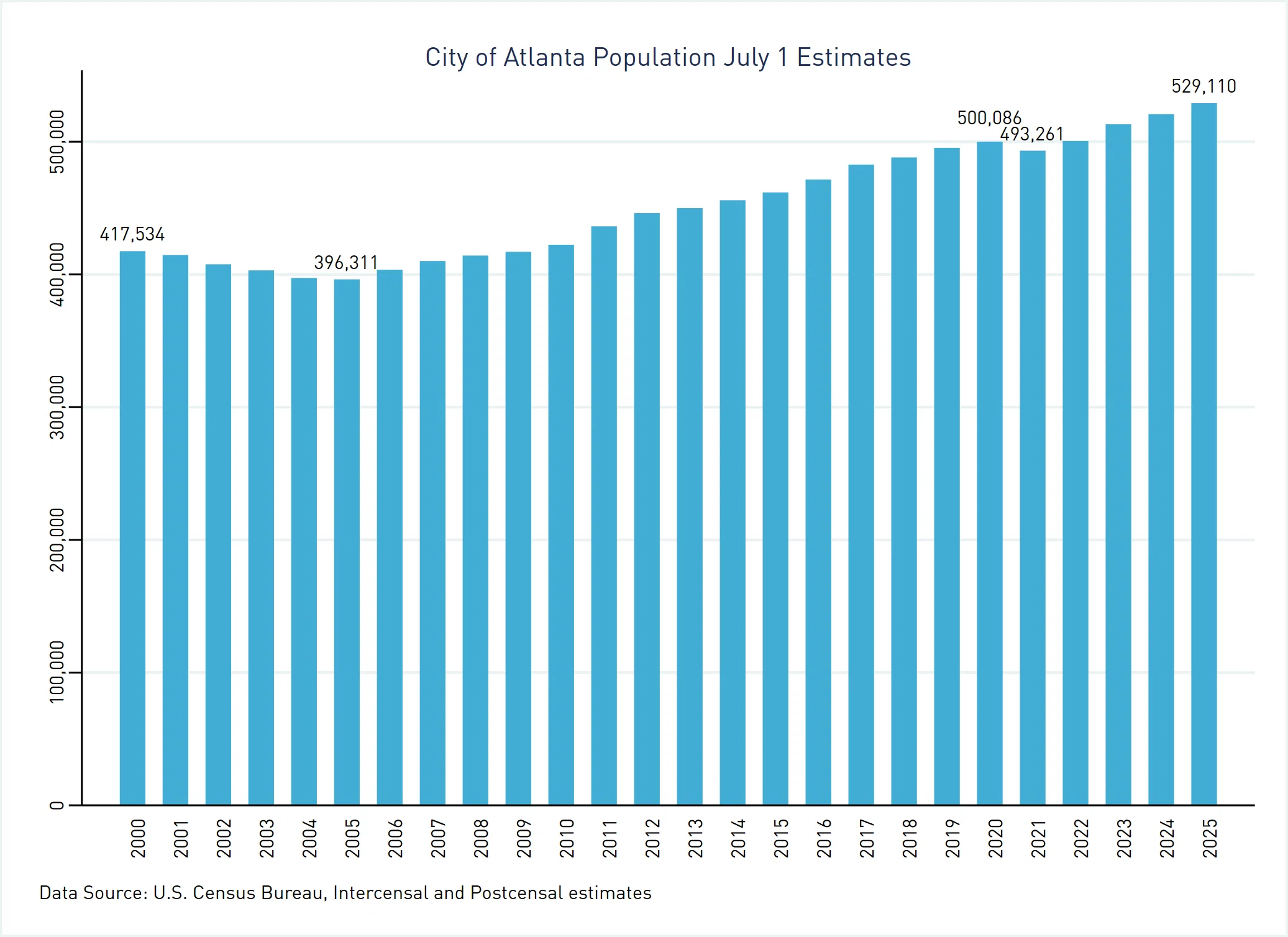
This graph shows that although the population of the City of Atlanta had recovered past the 400,000 mark between 1990 and 2000[5], population decreased again in the early 2000s, hitting a local minimum of 396,311 in 2005. Population has increased steadily since, reaching an estimated 529,110 by 2025. The Census Bureau estimates that Atlanta lost population only in the 2020-2021 period, a dip common to many major cities during the COVID-19 pandemic.
The Census Bureau’s City and Town Population Estimates provide both city totals and also numbers disaggregated by county. This allows us to compare growth rates for the portion of the City of Atlanta located in Fulton with the remainder of Fulton County and the DeKalb portion of the city with the remainder of DeKalb County. Figure 3 compares these growth figures over the period July 1, 2024 through June 30, 2025.
Figure 3: City of Atlanta’s Contribution to the Growth of DeKalb and Fulton Counties, 2024-25
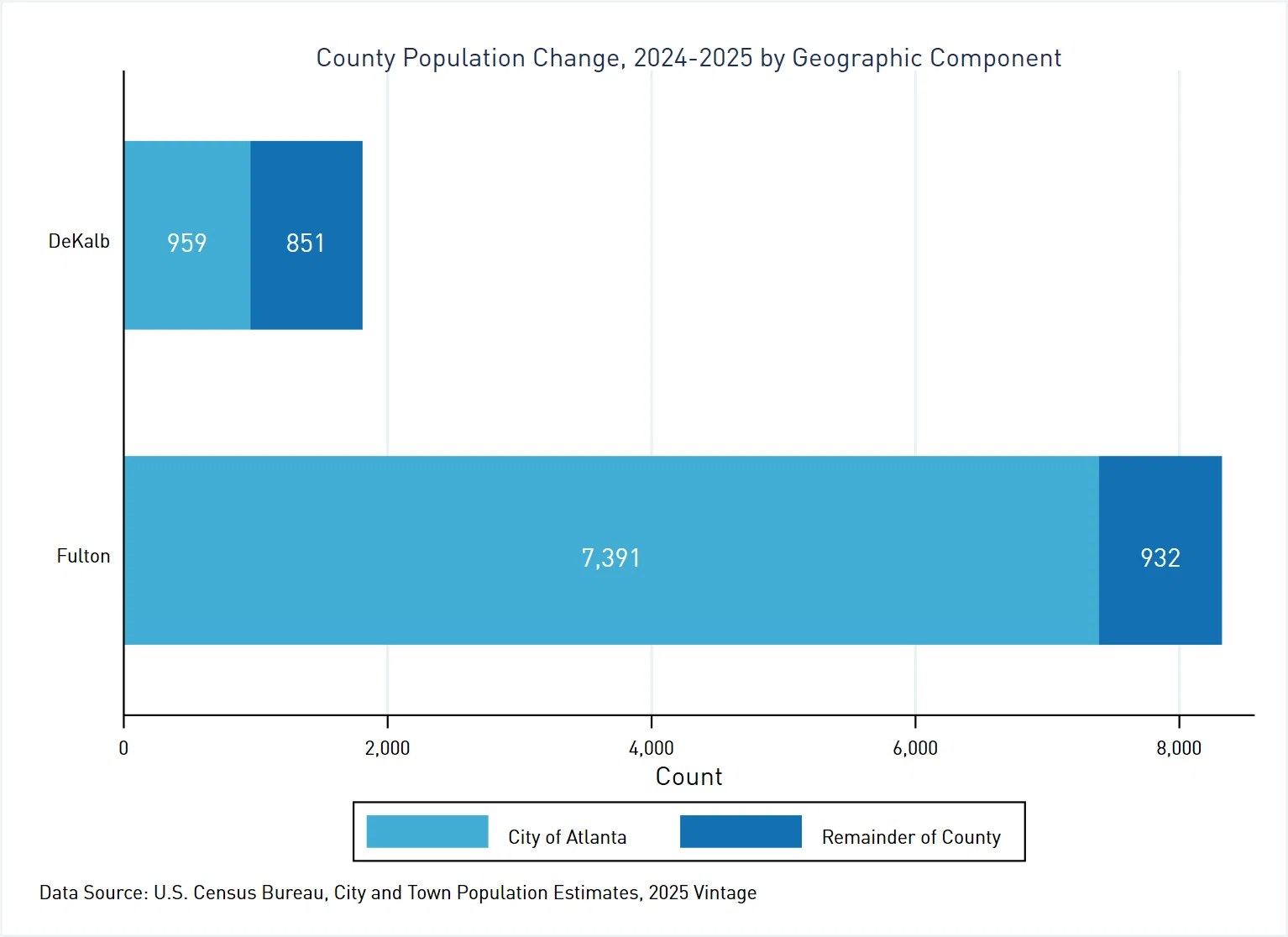
This graph demonstrates that, despite popular narratives about populations leaving central cities, the City of Atlanta was the primary engine of growth for both Fulton and DeKalb Counties in the 2024-25 period. Atlanta in DeKalb[6] provided for 959 (53%) of the 1,810 people added to the county, despite the fact that Atlanta in DeKalb only made up 5% of the county’s total population in 2020 and has only 3% of the county’s total area. The portion of Atlanta located in Fulton County contributed 7,391 (89%) of the 8,323 increase to the county’s population as a whole. To put this in perspective, the city accounted for 43% of the county’s population circa 2020 and has 24% of the county’s total area.
Figure 4 compares the same growth breakdown, but over a five-year time horizon from July 2020 through June 2025.
Figure 4: City of Atlanta’s Contribution to the Growth of DeKalb and Fulton Counties, 2020-25
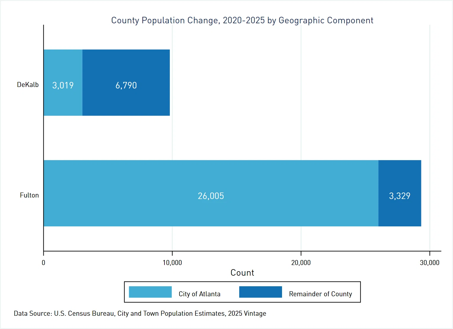
We see Atlanta as a growth leader was not just a single-year phenomenon. Atlanta in DeKalb accounted for 3,019 (31%) of the 9,809 increase in the overall county population. The portion of Atlanta in Fulton was responsible for 26,005 (89%) of the 29,334 total population increase for Fulton County.
Where is the growth occurring? While we do not have single year population estimates for small areas, we can use a proxy: change in the number of housing units. The Census Bureau has a relatively new product called the Address Count Listing File. These files come out twice a year to provide housing unit counts at the Census block level based primarily on USPS delivery address data. Comparing the counts between the July 2024 and July 2025 files gives us an idea where population is likely increasing. The dot density map in Figure 5 allows for this analysis; each green dot represents an increase of five housing units, randomly scattered within the Census block in which they are located.[7]
Figure 5: Housing Unit Count Change by Census Block, July 2024- July 2025
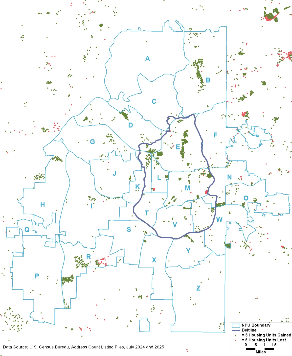
It is likely no surprise that much of the new housing is near the Atlanta Beltline. Moving clockwise around the trail, we observe strong growth in Old Fourth Ward (NPU M), Reynoldstown (NPU N), Grant Park (NPU W), Chosewood Park (NPU Y), and English Avenue (NPU L), Knight Park (NPU K), and Blandtown (NPU D). But we also see significant increases in the number of housing units in: Midtown (NPU E); Garden Hills, Buckhead Village, Buckhead Forest, and North Buckhead (NPU B); Southwest and Greenbriar (NPU R); Carroll Heights (NPU H); Bolton (NPU D); and the first phase of housing in the former Moreland Plaza shopping center.
In short, Atlanta’s recent population gains aren’t an anomaly. They’re part of a sustained pattern in which the city drives growth for both Fulton and DeKalb counties. Far from being full, Atlanta continues to absorb new residents and housing at a pace that reshapes our region’s demographics.
Notes
[1] As odd as it may seem to people who migrated from other parts of the U.S., it is not unusual for cities in Georgia to fall within the territory of more than one county. The City of Atlanta has 93% of its area and 92% of its population (according to the most recent– vintage 2025 estimates) in Fulton County, while the remaining 7% of its territory and 8% of its population are found in DeKalb County.
[2] Most notably the annexation of what is now NPU Q in 2006 and the Emory/CDC area, which joined NPU F in 2018.
[3] The Census Bureau produces two types of population estimates. Postcensal estimates, such as the recently released vintage 2025 data, extrapolate from the most recent decennial Census, utilizing data on births, deaths, and migration to estimate change. After the 2030 decennial counts are complete, the Census Bureau will improve the accuracy of the 2020-2030 time series on the basis of those counts. These intercensal estimates will interpolate between the 2020 and 2030 counts.
[4] Note that these population estimates are tied to July 1 of each year, while Census counts present figures as of April 1 of each decennial year.
[5] Possibly thanks to the Olympics?
[6] Atlanta in DeKalb is made up of the following neighborhoods, moving from north to south: Emory/CDC, the portion of Druid Hills inside the city limits, Candler Park, Lake Claire, Edgewood, Kirkwood, East Lake, and East Atlanta. The former Moreland Plaza currently under redevelopment is also located inside DeKalb County but is not part of any recognized neighborhood.
[7] There are also a few blocks that lost housing units, likely mostly redevelopment projects underway. Each red dot in the map represents a loss of five housing units in that particular Census block.