




Monday Mapday: Low Birthweight Births
Low birthweight is a key indicator of maternal and infant health. This map uses data from the Georgia Department of Health to show the rate of low birthweight births (where the infant weights less than 2,500 grams or 5.5 pounds) in metro Atlanta from 2009-2013. The highest rates occur in south Fulton and south DeKalb counties, with other [...]

Metro Atlanta Speaks: Will Living Conditions in Metro Atlanta be “Better,” “Worse,” or “About the Same” in 3 to 4 years?
For this month’s snapshot, we will be taking a look back at some of the results of the 2015 Metro Atlanta Speaks (MAS) survey, with a reference or two to previous editions of MAS. This annual survey—as of 2015—asked more than 5,000 individuals across 13 counties in the metro area questions about their perceptions and [...]

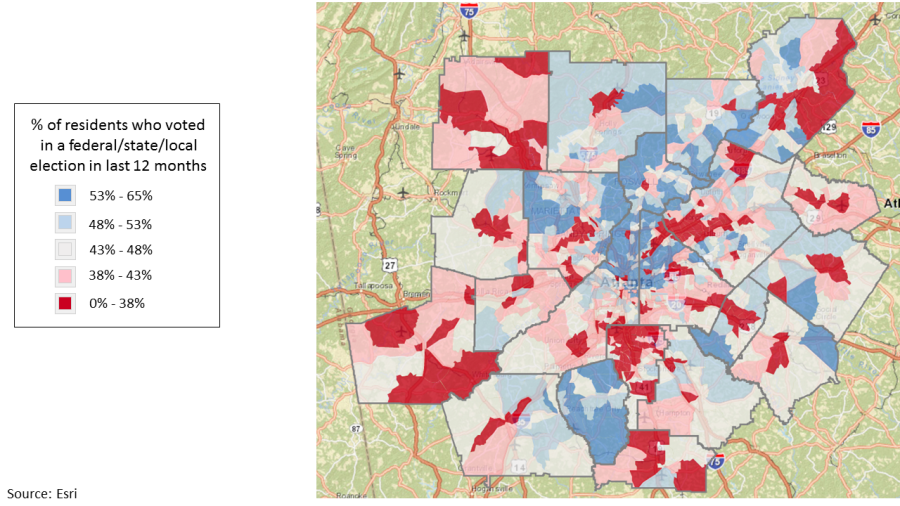
Monday Mapday: Voting in the last 12 months
It's time to get in the voting spirit! Are you an active voter? This map shows the percentage of residents who voted in a federal/state/local election in the last 12 months by census tract in metro Atlanta. One caveat: this is not actual voter registration data. The data comes from Esri's Market Potential database (“Civic activities and [...]

Where are Millennials renting and buying?
OK... we heard you! In response to the great feedback we received on the "Monday Mapday: Millennial Homeowners" post, we decided to further explore this topic. These maps show a more complete picture - they show where Millennials are both renting and owning homes. As you'll see, two completely different patterns emerge. But, before we get there, let's look [...]

Transportation Tuesday: Gotta Get Home On Friday
This week's Transportation Tuesday compares congestion (travel speed) for the past two Fridays: January 15 (the Friday of the Martin Luther King, Jr. Day weekend) and January 22 (inclement weather with winter conditions). The video below from INRIX shows travel speeds on the interstates in the 10-county metro Atlanta area for January 15 (left side) [...]

Monday Mapday: Millennial Homeowners
This map shows the percentage of owner-occupied housing units headed by a Millennial (age 18-34) in metro Atlanta. The areas in pink have the highest concentrations of Millennial homeowners. This map was created with Neighborhood Nexus. Explore other variables by using the Weave mapping tool.
January’s Regional Snapshot: Mid-Wage Jobs In Metro Atlanta
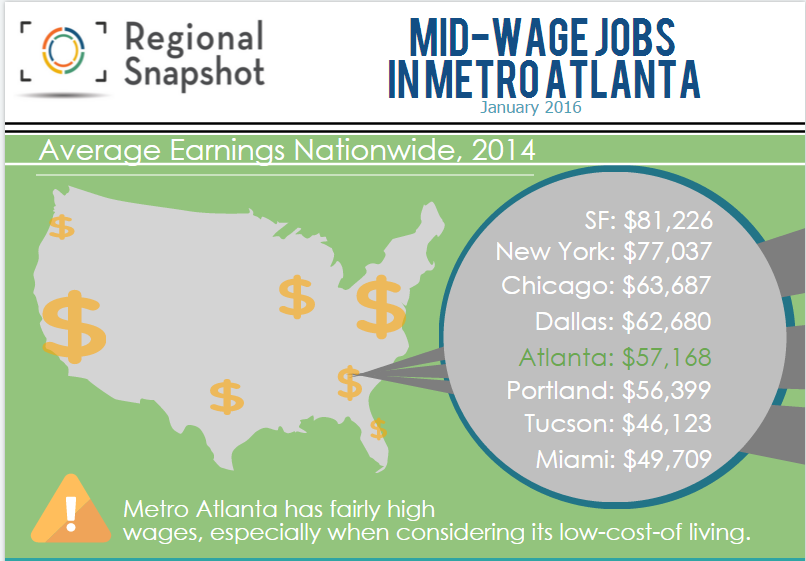
https://magic.piktochart.com/output/10456896-middle-income-snapshot The topic of the decline of middle-wage jobs is a hot topic nationally. So, this month's Snapshot explores this topic. While wages are declining for most workers, those stuck in the middle have seen some of the largest declines since 2010. Here are some of the highlights of our research: Considering its low cost of living, [...]