
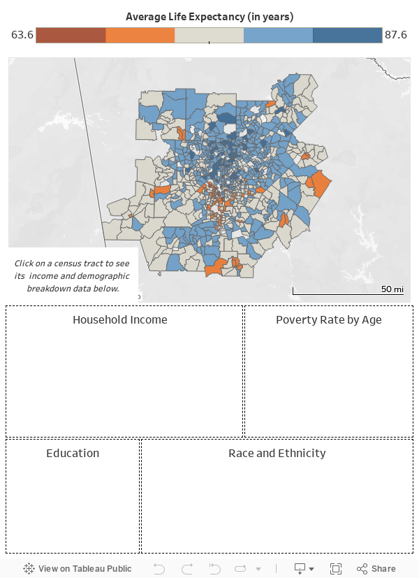
Based on recently-released data from the U.S. Small-area Life Expectancy Estimates Project (USALEEP), average life expectancy can be shown to vary greatly across relatively short distances in the U.S., with income, race/ethnicity, and education being the primary drivers of these differences. Produced through a partnership between the Robert Wood Johnson Foundation (RWJF) and the National Association for Public Health Statistics and Information Systems (NAPHSIS), this data includes estimates of life expectancy for most census tracts in the United States between 2010 and 2015. Comparing census tracts in the Atlanta Metro region, the data shows a 24 year gap in the estimated average life expectancy of residents. The physical distance between the tract with the highest average life expectancy (87.6 years) and the lowest (63.7 years) is only about 5 miles.
The interactive map and data dashboard below were created to help our readers visualize the USALEEP life expectancy data alongside income, poverty, education, and race/ethnicity breakdowns for census tracts in the Atlanta metro region. Click on census tract on the map to see its associated data.
Data sources:
National Center for Health Statistics. U.S. Small-Area Life Expectancy Estimates Project (USALEEP): Life Expectancy Estimates File for Georgia, 2010-2015 – released 2018.
U.S. Census, American Community Survey (ACS), 5-year estimates, 2012-16